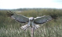
 A high-tech project to help scientists discover more about Ireland’s declining Hen Harrier population is underway in the Duhallow region thanks in no small part to support from the local community.
The cutting edge satellite-tracking project is a collaboration between IRD Duhallow (the community focussed Integrated Rural Development body for the region) and the National Parks and Wildlife Service (NPWS). It is backed and supported by the broader Duhallow community.
The Duhallow region spans much of North Cork and East Kerry the
 Satellite tracking will provide crucial information that has been unavailable to scientists to date. It will tell the programme team where young harriers disperse to once they fledge the nest, which habitats they gravitate towards, how far they range, how many young harriers die and much more. It will also serve to augment and support the substantial body of research undertaken by the Irish Hen Harrier Winter Roost Survey, helping researchers to pinpoint new winter roost locations, and establishing possible links between breeding and non-breeding areas for these threatened birds of prey.
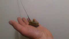
Advances in satellite tracking technology mean that devices weighing as little as 9.5 grams can be fitted to fledgling hen harriers without having a negative impact on the birds’ ability to fly and hunt effectively.
“The Duhallow Hen Harrier Satellite Tracking project has been borne from the desire of the Duhallow community itself to help the remaining Hen Harriers and hopefully ensure that future generations can continue to see and enjoy food passes and sky dancing on Duhallow’s rolling hills,” writes programme coordinator Barry O’Donohue on the new Irish Hen Harrier blog.
You can follow the progress of the project via regular updates on the Irish Hen Harrier satellite tracking programme blog, and of course we’ll be reporting significant milestones here on the Ireland’s Wildlife website.
Photo Credits: The Irish Hen Harrier Satellite Tracking


